
Introduction Video
The Basics
MyTrax GPS basically consists of three pieces:
- A cloud-based administrative console where you will set up your mapping elements and vehicle trackers
- The trackers themselves, transmitting vehicle locations and passenger data (if enabled)
- The maps your customers or dispatchers will use to view your vehicle/fleet positions, routes, stops, etc.
Administrative Console
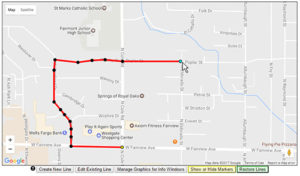
Creating a Line/Route in the Admin Console
This is where you will set up your system and define what your customers will see when they view your live tracking maps – route lines, stop markers, shuttle/vehicle icons, and other easy customizations. Access our web-based (in the cloud) system from anywhere you have internet access. You will be able to create user accounts with different levels of privileges so your entire team can manage the resources they are responsible for.
Each screen of the administrative console is designed to be simple to use, with intuitive tools, tutorial videos and documentation, and helpful tips that will walk you through each process. The entire system was designed to be easily managed by people with zero technical expertise. Relying on a vendor or an IT specialist to help you every time you need to make a change to one of your bus routes can drag down your entire operation. With MyTrax GPS, those sorts of changes are as simple as drag-and-drop.
One of the many great parts about this system is that it allows you to customize your maps to be unique to your organization. From the icons that represent your bus stops, to the thickness of the lines representing shuttle routes, everything is easily customizable to suit your preferences and branding requirements.
GPS Trackers
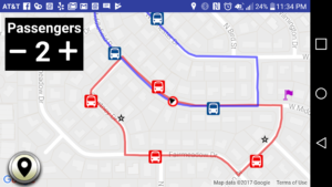
Driver’s view using the MyTrax GPS app
Tracking the position of your vehicle fleet can be done on any GPS-enabled smart phone or tablet. Whether you want to use an Android, Apple, or Miscrosoft device, we have an interface that will work for you. By far the easiest method is to download the MyTrax GPS mobile app, located in the Google Play Store or the Apple App Store. Using the app, your drivers can simply enter their tracker code and start driving. While their screen is on, they are able to view their position on the map, as well as the positions of your other vehicles. If the feature is enabled, they can also use the app to keep a count of their passengers — important data for reporting. The app will track in the background even if the device’s screen is powered off or the app is minimized, helping to conserve battery life and prevent accidental interruption in the service.
But you don’t need the mobile app to use MyTrax GPS. The service will run directly from the web browser of virtually any GPS-enabled mobile phone or tablet! This means that you can use virtually any mobile device to track your fleet vehicles, as long as it has a web browser and a data connection (cellular or WiFi).
Real-time Maps
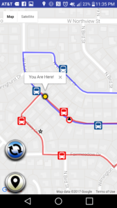
Customer map view using the MyTrax GPS app
Of course, the end goal is to display maps that your customers or dispatchers can use to know where your vehicles are. MyTrax GPS offers multiple options for you to give your customers access to this information. Using the MyTrax GPS mobile app, customers can simply enter a code to start viewing your map right on their phone. You are also able to embed the maps into your website design, retaining your company branding. Or you can link directly to the maps online. You can even embed the map into your own custom-built application! We do not want to limit you in any way when it comes to getting your maps into the hands of your customers.
Whether you run an airport shuttle fleet, a campus shuttle bus service, a tram, or any other transportation service, MyTrax GPS has a complete solution to display your vehicle positions to your customers and dispatchers. Sign up for your zero obligation 60 day free trial today!